
- Home
- Product Updates
PRODUCT UPDATES
See what’s new at Planet, check the announcements below
- 95 Product Updates
Originated as a Community ideaJun 18, 2026
New in Tasking: Set Watchers
Keep your whole team in the loop, automaticallyWe're excited to announce Set Watchers, a new feature in the Tasking Dashboard that lets you bring the right people into your order updates from the moment an order is created.What it isWhen you create a Tasking order, you can now specify additional email addresses that should receive notifications as that order progresses. The people you designate are automatically kept informed at every stage of the order lifecycle, right alongside you.Why it mattersStop manually relaying status emails to colleagues. Everyone who needs an update gets it the moment it happens. Key stakeholders stay in sync automatically, so your team can act on order progress without waiting to be looped in. Updates reach exactly who should be receiving them — and no one else.How to use itStart creating a Tasking order as you normally would. In the order creation flow, add the email addresses of the colleagues you'd like to keep informed. Submit your order — your watchers will automatically receive order-progress notifications going forward. A few helpful details:Watchers must have a Planet account within your organization and access to Tasking, so updates only ever reach authorized people. The emails will be sent from “noreply@planet.com”.Built with security and privacy in mindThis feature was developed with rigorous security review. To protect user data, the Dashboard does not expose any email validation or confirm whether a given address exists — you'll simply see a message confirming that notifications will be sent to eligible users. This keeps email addresses private while ensuring updates reach the right people. We'd love to hear how Set Watchers fits into your workflow and any feedback you have for us.
Related products:SkySatTanagerPelicanAccess Data
May 18, 2026
Updates to Visual Mosaic Compression
Planet is updating the compression scheme used for our standard visual mosaic products. We currently distribute visual mosaic data as LZW-compressed geotiffs with 8-bit RGB data. Starting on June 1, we will transition our visual mosaic products to use JPEG-in-tiff compression instead. This change will significantly reduce file size, making your data faster to download and easier to store and handle. Importantly, the file format (geotiff) and data content (8-bit RGB data) are remaining the same, with only the compression scheme changing. Similarly, internal overviews and tiff metadata are remaining unchanged. We've conducted internal validation and found no impact from this change on human viewers or on ML models. The change applies across all distribution channels, including downloads from the Basemaps API or Orders API and streaming through the Mosaic Tile Service. We expect the majority of software used to read mosaic data will continue to function seamlessly. However, if you are using older or highly specialized software, you may encounter compatibility issues. If this happens, please reach out to Planet Customer Success or Support for assistance.
Related products:Planet Mosaics
NewsMay 5, 2026
Introducing Visual Analysis and SuperRes PlanetScope Scenes
We're excited to share that on May 5th, two new capabilities are landing in Planet Insights Platform: Visual Analysis, a redesigned browser-based imagery tool, and SuperRes PlanetScope Scenes, an AI-powered enhancement for PlanetScope data available directly within it.Whether you're monitoring agricultural fields, tracking infrastructure changes, or mapping land cover, these tools are designed to help you get more out of your Planet data — faster and without leaving your browser. Visual Analysis (Beta)Visual Analysis is a new way to browse, visualize, and analyze your Planet data collections directly in the browser — no downloads or additional software required.If you've used Browser before, you'll find a familiar foundation but with a streamlined, collection-first interface and new capabilities built in from the start. Visual Analysis is launching in beta and will eventually replace Browser as the primary imagery analysis tool in Planet Insights Platform.What you can do:Browse your collections on a map — AOI footprint geometries appear as overlays so you can instantly see where your data livesSwitch between visualization layers — True Color, False Color (NIR), NDVI, and more, all driven by your configurations Navigate acquisition dates — step forward and backward through available scenes, or set a timespan to view a mosaic of all scenes in a period Run statistical analysis — select a pixel or draw an AOI to generate a time series chart for any index layer (great for NDVI trends over a crop cycle or deforestation monitoring) Measure on the map — quickly measure distances and areas directly in the interface Take the Introduction to the Visual Analysis Application course on Planet University to learn more! SuperRes PlanetScope Scenes — See More in Your PlanetScope DataAlso launching inside Visual Analysis: SuperRes PlanetScope Scenes, an AI-powered enhancement that increases visual detail in PlanetScope imagery beyond the native sensor resolution.SuperRes works on PlanetScope data you've already ordered and delivered to a data collection — no reordering needed. If your collection is compatible (using ortho_analytic_4b_sr or ortho_analytic_4b assets), you'll see a SuperRes hint next to the collection name.Applying SuperRes is straightforward:Select a compatible PlanetScope collection and visualize it on the map Draw an AOI between 0.5 and 10 km² using the map toolbar Click SuperRes under the AOI tool — processing runs automatically Use the toggle to switch the enhanced layer on and off to compare with the originalSuperRes also includes a Confidence Layer: a pixel-level overlay to help assess the degree of trust in the generated pixel by evaluating various sources of error. You can set a confidence threshold to hide low-confidence pixels and focus your analysis on the most trustworthy results. For more details on the SuperRes model read the following articles on Planet Pulse: Planet SuperRes: A Technical Overview and SuperRes is Now Available to See the World More Clearly. Take the Introduction to Planet SuperRes course on Planet University to learn more! How to Get Started You can access Visual Analysis from within Planet Insights Platform:> Analyze > Visual Analysis (BETA)You'll need an active Planet Insights Platform account with processing units. If you already have PlanetScope data ordered and delivered to a data collection, you're ready to go — your collections will appear automatically.Full documentation is available here: Analyze Imagery in Visual Analysis.For a deeper look at what's in this release, see our blog post: Planet SuperRes Is Now Available; See the World More Clearly.SuperRes Mosaics are also available. Learn more about Planet SuperRes. We Value Your FeedbackVisual Analysis is currently in beta, and your insights are crucial in helping us refine the experience. Once you’ve had a chance to explore the new tools, we’d love to hear from you:What workflows are you using it for?Are there features from Browser you'd like to see added?How does SuperRes perform on your data? Drop your thoughts in this thread — we're reading everything and will be responding actively in the first few weeks after launch.
Related products:PlanetScopePlanet Insights Platform
NewsApr 23, 2026
Change to GetCapabilities Response Logic on Planet Insights Platform
We have updated our OGC service endpoints (WMS, WCS, WFS, WMTS) to align discovery with regional data collections. By ensuring that only functional layers are listed in a request, we provide a more reliable experience and better consistency with OGC standards. What’s New?The GetCapabilities request is now region-specific.Previously, the eu-central endpoint often served as a global directory. Moving forward, each regional endpoint will only return layers for the data collections hosted within that specific region. How does this affect you?If your application fetches layers using a single GetCapabilities call to the eu-central endpoint, layers linked to collections hosted in other regions will no longer appear in your results.To access these layers, you must point your request to the corresponding regional endpoint:EU Endpoint: Planet data, Sentinel and Copernicus DEM https://services.sentinel-hub.com/ogc/wms/<INSTANCE_ID> US Endpoint: Landsat, HLS, Mapzen DEM https://services-uswest2.sentinel-hub.com/ogc/wms/ Please note that your own data collections (BYOC) will also only appear on the endpoint corresponding to the region where your data is ingested. Action RequiredIf your workflow utilizes a mix of global collections, please update your application logic to query the specific endpoint associated with each dataset.For a complete list of which collections reside on which endpoint, please refer to our Public Data Documentation.
Apr 20, 2026
ARPS v1.1.0
ARPS version 1.1.0 delivers significant enhancements to image quality and consistency, primarily through a refined approach to scene stacking and merging. This minor release introduces a new feature—refined scene compositing—which increases clear-sky coverage and brings substantial improvements to radiometric and geometric performance, as well as cloud mask accuracy. These updates ensure a more seamless, robust, and reliable product, especially in challenging imaging conditions. Note also that selecting the “best” scenes in a cloud-mask-aware way may lead to visible discontinuities where different scenes meet. See the examples at the end of this document. Improved Image Quality and ConsistencyNew Feature: Refined Scene CompositingThis release introduces a new process for combining multiple PlanetScope observations for a given date. Instead of selecting scenes before harmonization, the system now merges scenes acquired from each satellite into strips, harmonizes the strips individually, then aligns and merges them, stacking the best scene on top. When an area of the best scene is flagged as cloud-contaminated, that region is replaced by clear-sky pixels from the next-best scene from the same day (where available). This results in: Increased Clear-Sky Coverage: By leveraging pixels classified as clear-sky from all available scenes (from different satellite strips), we can now deliver a more complete, cloud-free product. More Consistent: The process uses cloud masks to identify and preserve clear-sky pixels, ensuring smooth, invisible transitions across scene boundaries.Additional ImprovementsThe processing was adjusted to collect images that are strip-specific rather than solely by date. The processing now stacks images within each satellite strip first before harmonization and alignment, which are then combined into a final tile. This results in significantly improved radiometric and spatial consistency between overlapping strips and between adjacent tiles. Radiometric ImprovementsSeveral modifications enhance the accuracy and consistency of surface reflectance data:Improved Topographic Corrections: The robustness and accuracy of corrections for rugged terrain have been enhanced. The band-specific correction factors are now recalculated using a model trained on initial values as a function of illumination condition, sun elevation, sun azimuth, and aerosol optical depth. Robustness Against Imperfect Reference Data: The radiometric harmonization process is now more resilient to imperfections in the FORCE reference data. The system now downweights lower-quality FORCE observations, reducing outliers in the time series and ensuring a more robust calibration. Improved Quadrant-to-Quadrant Consistency: Several operations now occur at the tile level rather than the inner-tile level, significantly reducing discontinuities within an AOI. Handling of "Suspect" Imagery: Imagery flagged as "bad" due to indications of incorrect radiometry will now be retained in the final SR raster (masked in QA Band 1 with values of 7, “suspect”) if no better image is available. This reduces instances of completely missing tile/quadrant data. These scenes will be included in “PERCENTAGE_BAD_RADIOMETRY” totals (see “Metadata Improvements”). Reduced incidence of Gibbs artifacts: Gibbs artifacts (“ringing”) near nodata boundaries have been significantly reduced, although they may still occur. Cloud Mask ImprovementsThe accuracy of cloud and haze detection has been refined:Refined Cloud Verification: The cloud mask verification process has been updated to reduce both false positives (commission errors) and false negatives (omission errors). Haze Detection Improvements: Aerosol Optical Depth (AOD) measurements from MODIS are now used to validate and augment UDM haze detections, helping to remove erroneous haze flags on days that MODIS indicates are clear and to mark entire regions as “haze” when the overall atmospheric conditions are poor. Fix for Backfill Data: A fix was implemented to ensure that invariant features are correctly calculated for early data in a backfill, which will positively impact cloud masks and radiometry during those initial periods. Flag “Suspect” Pixels Near Nodata Boundaries: Narrow strips of pixels near nodata boundaries may now be marked as “suspect” when geometric shifting has increased uncertainties in their radiometry. Geometric ImprovementsDecreased Incidence of Geometric Outliers: The refined scene compositing approach ensures more robust geometric harmonization. Identification of Geometric Errors: Images with significant geometry errors (e.g., heavy contamination, fuzziness, or rectification issues) are now flagged as "suspect" (mask value 7) and included in “PERCENTAGE_BAD_GEOMETRY” totals (see below). These will be kept in the final product if no clear scenes are available, consistent with the image quality update above. Metadata ImprovementsApproximate Per-Band Statistics: Surface reflectance band statistics (mean, standard deviation, minimum, maximum, and valid percent) are now computed from the SR rasters and included in the GeoTIFF metadata for all bands. Color Interpretation for NIR Band: Color interpretation metadata is now set for the NIR band, which previously had only been set for the RGB bands. This improves compatibility with GIS tools that rely on band interpretation metadata. STAC Item Metadata: Metadata keys that were previously only available in the header of the QA rasters are now also included in the corresponding STAC items. Additionally, per-band raster:bands metadata (including data type, nodata, spatial resolution, scale, and offset) is now reported for both SR and QA assets, and band-level statistics (mean and valid percent) are included in STAC item deliveries.. STAC Item Delivery to Bucket: STAC items and catalog files are now delivered directly to customer delivery locations alongside the raster products. Scene Quality Metadata: Provided metadata fields now include “PERCENTAGE_BAD_GEOMETRY” and “PERCENTAGE_BAD_RADIOMETRY” keys which provide scene-level quality measures. Image Discontinuities due to Best-on-top SelectionThe newest version of ARPS uses cloud mask labels to determine the “best” scene. This means that, depending on what scene data are available and how those pixels are classified, portions of cloud, shadow, or haze features may be replaced by data from different scenes, creating discontinuities. The result is intended to provide users the best available of the contaminated data, increasing usability for analytic applications. This can sometimes come at the cost of introducing abrupt transitions between portions of scenes. Note that scenes are blended together at the boundaries to reduce transition artifacts, but that contaminated regions are never blended into clear regions. We may, however, blend between differently-contaminated regions (e.g. a region with haze from one scene bordering a region with cloud shadow from another scene).Prioritization for scene selection by cloud classification runs: Clear > haze (4) or other contamination (6) > cloud shadow (3) or adjacent clouds (5) > suspect (7) or bright clouds (2). Please refer to the ARPS tech spec (section 4.6) for more details on scene merging. See below for an example of this effect. All images are from the same day, taken from a particularly cloudy area. On the left is the output of the previous ARPS release (v1.0.1) and on the right is an image produced for the same day and same region by this release (v1.1.0). The second row is an expanded view of the image on the top. Note that ARPS v1.1.0 has a significant improvement in the cloud-free area available. Some of that cloud-free area comes in the form of a cutout removed from a large cloud shadow, creating an abrupt transition. The scene provenance mask (QA layer 2) will indicate which pixels come from which scene, and the cloud mask (QA layer 1) will indicate which pixels are classified as clear, cloud, cloud shadow, etc.
Related products:PlanetScope
Apr 15, 2026
Introducing Tasking Credits for Access to Tasked Imagery
We are excited to announce a major enhancement to how our Tasking customers use Tasking Credits to access and utilize our archive imagery. The new feature is designed to simplify workflows providing easier access to archive data.This initiative closes the gap for Tasking customers, allowing them to access data directly through Planet’s core delivery tools.Key Benefits of the UpdateEnhanced User Experience Users will gain the ability to use Tasking Credits to directly order and subscribe to archive data using Planet’s core delivery UIs and APIs. This provides improved deep search functionality, data preview, and the ability to compare tasked archive data with other imagery products. Efficient Multi-User Ordering Organizations will be charged Tasking Credits only once per asset. If multiple users within an organization order the same asset (e.g., the same ortho_visual asset from a SkySat Collect item), only the first order will incur a Tasking Credit charge. Support for New Missions This feature supports customers utilizing new missions like Pelican and Tanager, enabling them to access their archive data through Tasking Credit via our main delivery tools.Important Ordering DetailsClipping and Minimums: Clipping is supported for workflow convenience. However, please note that it costs the Tasking Credit equivalent. Minimum charges are in place. These minimums are detailed in the latest Terms of Services page. Tasking Credit Scope: Tasking Credits are designated for ordering Tasked imagery only (like SkySat, Pelican, and Tanager) and cannot be used to purchase PlanetScope imagery. Data Previews: Low-zoom previews are available to all users. Higher-zoom previews or streaming require a separate tile-view quota purchase. We’re excited to see how these improvements speed up your insights. As always, we’re looking forward to your feedback via Planet Community!
Related products:Planet Insights Platform
BlogMar 25, 2026
Planet Launches New Initiative on Planetary Security
On a volatile and changing planet, the landscape of security risks is expanding, and our notion of security must expand with it.This is the central premise behind our new Planetary Security Program, which uses Planet data and tools to help address a broad landscape of security concerns that are shaping 21st-century competition and conflict.The program focuses on eight intersecting thematic areas: Climate Security, Nature Security, Human Security, Food and Water Security, Biosecurity, Energy and Materials Security, Critical Supply Chains, and Peacemaking and Peacebuilding. Each of these domains present risks that act as threat multipliers to traditional security concerns, blurring the lines between international security and the resilience of global institutions and systems. See the full article on Planet Pulse: Planet Launches New Initiative on Planetary Security
NewsMar 18, 2026
Self-Serve Automated Delivery: Faster, Smarter, and Completely In Your Control
In January, we introduced Automated Delivery to help you skip the manual downloads in Planet Explorer. Today, we’re taking it a step further. We’ve overhauled the system to give you total control and faster speeds. What’s New?We’ve implemented two major upgrades to the Tasking Dashboard experience:Direct Bucket Management: You can now set up and manage your own automated delivery bucket directly through the Destinations UI. You no longer need to contact your Planet representative to link your bucket. Reminder: As an opt-in feature, you will need to contact Planet Tech Support to enable Automated Delivery. You only need to do this once. Flexible Destinations: You have the freedom to switch or update your cloud bucket destinations at the time of order ingestion, giving you full agility over your data pipeline. Why This MattersThis update reduces "friction" and improves latency. By removing the manual setup steps and increasing transfer speeds, we’ve turned a multi-step coordination process into a seamless, self-serve experience. You task the imagery; we handle the rest—instantly. Get Started in Two StepsYou no longer need to reach out to Tech Support to set up a destination. However, because it’s currently an opt-in feature, please contact Tech Support to enable Automated Delivery. You can handle the entire setup yourself:Configure: Head over to the Destinations UI to set up your S3-compliant cloud bucket. Order: Select your preferred destination within the Tasking Dashboard at the time of ordering, and receive your specified assets to your cloud bucket. Supported AssetsThis feature remains available for all Tasking customers, including those utilizing our newest missions, Pelican and Tanager. Note: If you previously had a destination set up, you can still view and manage it within the Destinations UI, or create a new one to take advantage of the updated speeds.We’re excited to see how these improvements speed up your insights. As always, we’re looking forward to your feedback via Planet Community!
Related products:APIsSkySatTanagerPelican
NewsMar 16, 2026
Sunset of Third-Party Data Import (TPDI) API for Planet data
On February 11, we announced the deprecation of the Sentinel Hub Third-Party Data Import (TPDI) API for Planet data. Today, we are sharing important updates to help you navigate this transition until the official TPDI service sunset for use with Planet data on November 11, 2026. Delivering Data to Data CollectionsMoving forward, all new Planet data orders and subscriptions should be managed through the Planet Insights Platform. This applies whether you are delivering to a new data collection or to an existing one. To ensure a smooth transition, we recommend the following transitions when delivering to a new data collection:API Users: If you use the TPDI API for ordering and subscribing to Planet data, please transition to the Orders API or Subscriptions API. We prepared a dedicated FAQ entry to help you with the API transition. EO Browser (Ordering): If you use EO Browser for ordering Planet data, please switch to Planet Explorer. EO Browser (Subscribing): If you use EO Browser for subscribing to Planet data, please switch to the new tool for creating subscriptions. Update on Existing TPDI Data CollectionsPreviously, we advised users to continue using the TPDI API to deliver to existing data collections until further notice. That transition path is now available.Your existing TPDI Planet data collections are now visible and manageable within the Planet Insights Platform Data Collections (under the PLANET tab). This integration allows you to:Deliver New Data: You can now direct new Planet Orders or Subscriptions to deliver to these existing data collections. Keep Existing Subscriptions: Your existing subscriptions will keep delivering the data. On November 11, 2026, they will be automatically migrated to Planet Insights Platform. Looking Ahead: Sunset TimelineOn November 11, 2026, the TPDI API will be fully sunset for use with Planet data. At that time, the following functionalities will be removed from the TPDI API:Creation of new orders or subscriptions. Listing or managing existing orders/subscriptions. Original data downloads. Automatic Migration of Active SubscriptionsTo ensure continuity, Planet will proactively migrate any TPDI subscriptions scheduled to run past November 11, 2026 to Planet Insights Platform. If you have any questions or require assistance, please do not hesitate to reach out to Planet Support.
Related products:APIsAccess Data
NewsMar 11, 2026
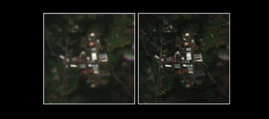
Crop Biomass V5: High-Resolution (3m) Daily Monitoring
Planet is excited to announce the launch of Crop Biomass Version 5! By integrating PlanetScope as our primary optical source, we have upgraded our daily, cloud-free signal from 10m to 3m spatial resolution. This increase in spatial resolution is key for users working in regions dominated by smallholder farms and intensive cropping systems. Comparison of intra-field detail: Crop Biomass V4 (10 m) vs. V5 (3 m). What’s New?In addition to increased spatial resolution, we have introduced several technical enhancements:Enhanced Metadata: New metadata, such as the average NDVI (from the latest optical observation), the probability of snow, and the probability of water, have been added to the rasters to support the interpretation of the data. The full list can be found in the Technical Specification. Improved Signal Responsiveness: We have improved the responsiveness of the time series, reducing the lag between the Crop Biomass signal and NDVI by several days. This was achieved by transitioning from a "rolling mean" to time-series regularization, a technique based on this recently published paper. This ensures the data is more reactive to real-time field changes while maintaining a smooth, reliable signal. Removal of Spatial Seam Lines: Improvements were made to the data harmonization process, which led to better temporal consistency with Sentinel-2 and removed the spatial seam lines. How to Access?Crop Biomass V5 remains a fully analysis-ready product, delivered via the Planet Subscriptions API. Existing customers can access V5 immediately under their unified "10m + 3m" quota.Learn more in the Introduction to Crop Biomass course or see the Crop Biomass Datasheet or Crop Biomass Technical Specifications.
Related products:Planetary Variables
NewsMar 9, 2026
API Path Structure Updates for Sentinel Hub Services
We're updating the API path structure for several Sentinel Hub APIs to improve consistency across our APIs. This change will be gradually rolled out starting on Tuesday, March 17th over the course of the following week. Affected services:Processing API Asynchronous Processing API Statistical API Batch Statistical API Batch Processing API Catalog API Zarr Import API Bring Your Own COG (BYOC) API What’s ChangingAPI endpoints are transitioning from:Current format: /api/<version>/<service> New format: /<service>/<version> Examples: Current Format New Format /api/v1/process /process/v1 /api/v1/async /async/v1 /api/v1/statistics /statistics/v1 /api/v1/statistics/batch /statistics/batch/v1 /api/v2/batch /batch/v2 /api/v1/catalog/1.0.0 /catalog/v1 /api/v1/zarr /zarr/v1 /api/v1/byoc /byoc/v1 ImpactBoth URL formats will continue to work - No action is required from API consumers Response links will use the new format - Services that return self-referential links (such as Catalog and Batch APIs) will return URLs using the new path structure No breaking changes - All existing integrations will continue to function normally Action requiredNone at this time. We're rolling this out gradually starting Tuesday, March 17th. Please do not make any changes to your integrations at this time. Both the old and new URL formats will be supported.We're announcing this change in advance for transparency and to answer any questions you may have. Questions?If you have questions about this change, please reach out to our support team or post in the Planet Community forum.
Related products:APIs
NewsFeb 11, 2026
Deprecation of Sentinel Hub Third-Party Data Import (TPDI) for Planet Data
As we continue to integrate Sentinel Hub with Planet Insights Platform, we are announcing that the Sentinel Hub Third Party Data Import (TPDI) API is officially deprecated for use with Planet data. The API will be gradually sunset over the next nine months.We strongly advise that you move your workflows to the new experience at insights.planet.com and with the Orders and Subscriptions API. While no immediate action is required today, we recommend reviewing the details below to help you plan for your future workflows. Please note that this announcement pertains only to Planet data. If you have purchased Maxar data, you should continue to use the TPDI API. What is happening?The TPDI API workflows for ordering and subscribing to Planet data have been replaced by the Orders API and Subscriptions API. The EO Browser user interface for ordering and subscribing to Planet data has been replaced by Planet Explorer for ordering and a new tool to create subscriptions. These new tools are more integrated into the overall Planet customer experience and are where all future improvements will be added. How to prepare?When you order or subscribe to Planet data and deliver to a new data collection, we strongly encourage you to transition to using the Orders and Subscriptions API, or equivalent web applications, as soon as convenient. This will ensure your workflows are future-proof to the pending removal of the TPDI API. Depending on your workflow, we recommend the following actions: API Users: If you use the TPDI API for ordering and subscribing to Planet data, please transition to the Orders API or Subscriptions API. EO Browser (Ordering): If you use EO Browser for ordering Planet data, please switch to Planet Explorer. EO Browser (Subscribing): If you use EO Browser for subscribing to Planet data, please switch to the new tool for creating subscriptions. If you are delivering Planet data to an existing TPDI data collection, please continue using TPDI as usual until further notice. The ability to use Planet Orders & Subscriptions APIs with the existing TPDI data collections will be available and announced in the coming weeks. Please note that EO Browser will no longer be accessible on March 20, 2026 as announced: Important Update: Sunset of EO Browser and Sentinel Hub Dashboard. We are committed to making this transition as smooth as possible. A detailed deprecation plan and technical migration guide will be shared in the coming weeks to ensure your operational workflows continue without disruption.
Feb 5, 2026
Important Update: Sunset of EO Browser and Sentinel Hub Dashboard
Sentinel Hub web applications, including EO Browser and the Dashboard application, will no longer be accessible on March 20, 2026. As we announced in November 2024, Planet has been working to unify Planet and Sentinel Hub into one Earth observation platform for near-daily satellite imagery and cloud-based image processing. We sincerely appreciate all of our valued users of EO Browser over the 8+ years, and hope that you will continue to explore satellite imagery with our platform through Planet Insights Platform. You can find the new versions of EO Browser and the dashboard application that are now available at insights.planet.com. Head on over to the new browser application to explore and analyze data in the browser. All of your data collections and configurations are already available here - no manual migration is needed. The features of the Dashboard application are now found in different sections of Planet Insights Platform for Account, Data, and Analyze. From each of these sections, you’ll be able to monitor quota usage, manage data collections, and create new imagery configurations for OGC services. For Sentinel Hub Third-Party Data Import (TPDI) users, a dedicated communication will follow shortly to detail how to transition your workflows to Planet Insights Platform. If you have any questions or concerns about this migration, please reach out to Planet technical support. What happened to free access to Sentinel Hub? If you previously relied on free access to EO Browser, we invite you to take a look at Copernicus Browser. Developed under governance of ESA and the European Commission, Copernicus Browser is the tool to search for, visualize, and analyze data from the Copernicus Sentinel missions. We trust that you will find your way around the new interface in no time. You will recognize many features that you already know from EO Browser, but also new ones. To make the transition easier for you, we encourage you to take a look at our EO Browser to Copernicus Browser transition guide.
Related products:Planet Insights Platform
Feb 4, 2026
Planet Mosaics: Current, Complete, Analysis Ready
Planet Basemaps is our solution for providing comprehensive, high-frequency, visually stunning, and analysis-ready mosaics. For years, we have referred to them as both basemaps and mosaics. However, these two terms actually have slightly different meanings.A basemap typically refers to a visual backdrop for maps, apps, and analysis.A mosaic, in the geospatial sense, refers to a collection of raster datasets that have been stitched together into a single larger dataset. While also an effective visual backdrop, mosaics can also be used for raster and geospatial analysis and can power AI and machine learning workflows.Our solution supports all these workflows. So to provide better clarity, we have renamed Planet Basemaps to Planet Mosaics.Read the rest of the Planet Pulse article here.
Related products:Planet Mosaics
Feb 2, 2026
Ask AI MCP server
Did you know that you can use AI to ask your Planet related questions?!?! Using the Ask AI button on Planet Community, Planet Documentation, Help Center, Planet University, and Publications Database, you can search your question and it will sift through hundreds of documentation pages, Community results, courses, help center articles, and more! Learn more by watching this how- to video! Now a Model Context Protocol (MCP) Server is available to make asking AI even easier! If you’re deep in your codebase, context-switching kills flow. You hit a question and suddenly you're tab-hopping to a site to ask AI to get your answer.With the MCP, you just ask your AI coding assistant. Behind the scenes, it queries the same resources & materials and returns grounded, cited answers. No context switch. No guesswork. What is a Model Context Protocol (MCP)?The Model Context Protocol (MCP) is an open framework designed to let AI systems securely plug into external tools and data sources through a standardized connection layer. Rather than operating in isolation, an AI powered by MCP can tap directly into all of Planet’s documentation to give you results within your IDE. How to install:Simply click the Ask AI widget featured on: Planet Community, Planet Documentation, Help Center, Planet University, or Publications Database. Then reveal the MCP dropdown and here are the listed AI tools you can connect to. Here is an example of how it might look: MCP is supported by most major AI coding tools, including:Gemini - Add MCP servers in Settings Cursor - Add MCP servers in Settings → MCP Claude Desktop - Configure in Settings → Custom Integrations or via config file Claude Code - Run claude mcp add from the terminal VS Code (with Copilot) - Configure in settings.json Windsurf - Add to mcp_config.json ChatGPT Desktop - Via the Apps & Connectors settings
Related products:Planet Community
NewsJan 29, 2026
Automatically Deliver your Assets to your Cloud Bucket!
We’re excited to announce that customers can now automatically deliver their requested asset types to their specified cloud bucket directly using Tasking Dashboard.Starting now, you can opt-in to this feature to ensure your Tasking experience is faster than before. What is This Feature and Who is it For?Customers that are provisioned with Automated Delivery will be able to get their assets delivered to their choice of S3 compliant cloud bucket. The supported buckets can be found here.This feature is for all Tasking customers, including those with new missions like Pelican and Tanager. Why This Matters (The Problem We're Solving)Previously, customers had to go to Planet Explorer to order their tasked imagery. This feature ensures that the customers only need to task imagery, and the assets are automatically delivered to their cloud bucket so that they do not have to perform extra additional steps for downloading their image. Get Started Now! (Opt-In & Opt-Out)The feature is ready for you to use!Opting In NowTo get it enabled, simply reach out to Tech Support with the details of your cloud bucket or your primary Planet contact. The steps needed are:Setting up the Destination using Destinations UI Sharing the Destination Reference with your Planet PoC Important NotesIn this initial release, please be aware of the following current limitations:Involvement of Planet PoC: In the first release, after setting up your cloud bucket, you need to involve your Planet PoC, so that they can set up the destination for your organization.We're excited for you to experience this improvement and look forward to your feedback!
Related products:SkySatTanagerPelican
NewsJan 26, 2026
Introducing Waitlisting for Assured Tasking
In high-demand regions, securing the Imaging Window (IW) for your Assured Tasking order can be a challenge as those may already have been booked. You spend time monitoring for cancellations, often missing the fleeting opportunity when it finally appears. We’re solving this problem with the launch of Waitlisting for Assured Tasking, a powerful new feature designed to put your tasking on autopilot and ensure fairness. How It Works:Join the Waitlist: If your ideal IW is taken, simply join the waitlist with your order. Automatic Monitoring: Our system monitors the slot 24/7. Autobook: The moment the IW becomes available the system automatically books it for the customer next in line on the waitlist. The Value for Your Mission:Set it and Forget it: Eliminate the need for manual monitoring. Our automation handles the booking, allowing you to focus on analyzing your data. Fair & Flexible Access: We’re implementing a fair, first-in, first-out (FIFO) system, guaranteeing you a structured chance to capture slots that become available at the last minute.Ready to integrate this new capability into your workflow?➡️ See the implementation steps and full release plan here on the Planet Documentation site.
Jan 20, 2026
Google Cloud Storage for Asynchronous Processing & Batch APIs
We have expanded our Object Storage integrations to include native Google Cloud Storage (GCS) support.This update streamlines the delivery of derivatives from our platform into your infrastructure. You can now configure gs:// paths directly in your API requests to deliver outputs from Asynchronous, Batch Processing, and Batch Statistical jobs.What this means for your workflowIf your team operates within Google Cloud, you can now seamlessly bridge our processing capabilities with your storage environment. By configuring your credentials, you can route analysis results, COGs, and statistical outputs directly to your GCS buckets, removing the need for intermediary storage steps or complex cross-cloud transfer scripts.DocumentationFor implementation details and credential configuration, visit the Object Storage Configuration docs:Asynchronous Processing API Batch Processing API Batch Statistical API
Related products:APIs
NewsJan 14, 2026
New Experience for Creating Subscriptions
We have introduced a visual workflow for creating data subscriptions directly within the Planet Insights Platform web application.A subscription allows for you to request data based on an area and time range. It supports setting a time range that extends into the future, and all imagery that matches those filters is automatically delivered to you soon after Planet downlinks the image.This update brings the capabilities of our Subscriptions API into the browser. You can now establish continuous data monitoring feeds without writing code. What this means for your workflowIf you have a processing unit plan, you can now configure subscriptions visually:Define Areas of Interest: Select features from a feature collection, or draw directly on the map. Apply Filters: Select specific item types and metadata filters (e.g., max cloud cover). Automate Delivery: Set up persistent monitoring for new imagery that matches your criteria. Availability & Roadmap This feature is currently available to users with a processing unit plan who are delivering to data collections on Planet Insights Platform.We are actively expanding this tool to support cloud storage destinations. This upcoming update will unlock the visual subscription builder for all other account types, enabling seamless delivery to your own infrastructure.Getting Started You can access the new subscription builder here: insights.planet.com/data/subscriptions/new
Related products:APIs
NewsJan 12, 2026
Beta: Planet MCP Server for AI Agents
We have released an experimental Model Context Protocol (MCP) Server to bridge the gap between Large Language Models (LLMs) and Planet Insights Platform.This open-source tool allows AI agents—such as Claude for Desktop—to interface directly with Planet’s APIs. Instead of writing Python scripts for routine checks, you can now use natural language to search the catalog, preview imagery, and manage orders.Example of Claude Desktop using the Planet MCP server to find imagery.How it Works The server runs locally on your machine and uses your existing Planet SDK credentials. It translates natural language prompts into structured API calls, allowing your AI agent to act as a "copilot" for geospatial workflows.Core Capabilities in BetaNatural Language Search: Query the Data API using descriptive text (e.g., "Find PlanetScope imagery over Chicago from last week with <10% clouds"). Visual Previews: Request and view thumbnails directly in your chat interface before ordering. Asset Ordering: Trigger standard order workflows for visual bundles and other assets without leaving the conversation. Feature Management: Interact with your saved Feature Collections to define Areas of Interest (AOIs). Getting Started This project is currently in Beta and considered experimental software. We are looking for developer feedback on capabilities (e.g., statistical analysis, spectral visualization) you would like to see next. Please note that the MCP Server is provided without a guarantee of persistence or long-term support and may be modified or discontinued.Repository: github.com/planetlabs/planet-mcp Setup: Follow the README to configure the server with Claude Desktop or other MCP-compliant clients.
Related products:Planet Insights Platform
NewsDec 1, 2025
General Availability of Pelican Data Products
Pelican is Planet's next-generation high-resolution imaging constellation, designed for sharper imagery, faster tasking, and expanded spectral capabilities. Pelican maintains continuity with SkySat's 50 cm class imagery, but its next-generation architecture sets the stage for Planet to develop additional, high-resolution products.Presently, Pelican's larger mirrors and optimized optical system allows for 50 cm class resolution at high fidelity. Pelican's larger aperture at lower altitude captures more detail to deliver crisper images that analysts will be able to easily observed. Pelican's expanded spectral range enables deeper analytics, supporting applications across defense, intelligence, natural resource monitoring, and commercial sectors.Pelican is fully integrated into Planet's unified tasking platform, ensuring seamless access through the API and Tasking Dashboard. With shorter time to collection, expanded tasking windows, and near real-time tasking capabilities, Pelican is set to deliver faster insights and higher-quality intelligence for the world's most demanding applications. To learn more about Pelican see:Introduction to Planet High Resolution Satellites on Planet University Pelican Documentation
Related products:Pelican
NewsOct 21, 2025
Account App Updates
Product Lists In the 'Plans' tab for a given Organization, the 'Other Products' tab no longer shows Contracts -> Line Items.It now shows a list of products that you have access to. Products listed here include products like Global AUM, Tropical Basemaps, Processing Units (if purchased through insights.planet.com), Planetary Variables, & ARPS. Product DetailsClicking on one of these products shows a Product Details page, which brings back usage bars! It will also show a history which includes multiple purchases of the same product which will have 'fused' their quotas together.Access your Account Page here
Related products:Account Management
NewsOct 20, 2025
Improved Web Tools for Basemaps and Pixel Provenance API
Planet is excited to announce a new and improved web experience for using Planet Basemaps! This tool consolidates the existing functionality that you have in Basemaps Viewer and Explorer into a single place so you can more easily search for, visualize, analyze, and download data.If you have access to Planet Basemaps products, head over to the new experience to test it out: insights.planet.com/data/mosaics. We ask that you migrate your workflows to this new application before January 31st, 2026. At that time, Planet will sunset the legacy tools available in Basemaps Viewer.From this new application, you will be able to quickly find the Basemap that you have access to and browse them on the map and through the timeline on the bottom of the map for Basemap series. Imagery Interpretation ToolsOnce you find the Basemaps that you want to work with, you can use tools for imagery interpretation:Compare two Basemaps by swiping or comparing relative luminance. Enhance imagery by adjusting the contrast, brightness, and saturation Analyze with preset renderers for common spectral indices and false color composite Download Basemaps and Pixel ProvenanceIf you need to work locally with the Basemap, you can find and download quads within an area of interest that you draw on the map. And if you need access to the metadata for the source imagery that comprises the basemap, you can find this information through the pixel provenance tool. The pixel provenance tool will tell you what date the imagery was captured on and other metadata that you can use to order imagery. With this release, we have also publicly released documentation on this pixel provenance endpoint which you can learn more about in the Basemaps API documentation.
Related products:Planet MosaicsPlanet Insights Platform
Oct 8, 2025
Introducing Owl: Planet's Most Advanced Satellite Mission Yet
Since our founding in 2011, our mission has been simple yet bold: to make the Earth visible, accessible, and actionable. By pioneering a new approach to space, we built and now operate the world’s largest commercial network of Earth-imaging satellites. This effort has resulted in Planet’s core product: our global, near-daily scan, which has an unmatched data archive dating back to 2017, capturing years of near-daily imagery for every point of Earth’s landmass and offering unparalleled temporal depth for AI and analytics. Our global scan is a core element of our business, and remains unprecedented in Earth observation.That’s why today we’re excited to introduce Owl™: our next-generation monitoring fleet….Check out the rest of the blog post on Planet Pulse!
Sep 29, 2025
Data Collections in Planet Add-in for ArcGIS Pro Version 3.4
Planet has released version 3.4 of the Planet Add-in for ArcGIS Pro. With this update, we’ve added features to allow you to work with cloud data collections on Planet Insights Platform. Data collections are a way for you to store data that you order in the cloud, rather than downloading it locally. This enables you to save time spent downloading and managing data on your computer, and more easily share imagery with collaborators without having to transfer large amounts of data.Data Collection Delivery DestinationWhen you order imagery in ArcGIS Pro, a new delivery destination option is available for Data Collection. If you use this option, data will be stored in the cloud on Planet Insights Platform, and you will be able to access the data through OGC services that you can use to stream imagery into ArcGIS and other geospatial tools. You won’t need to download the data, manage large files, or create mosaic datasets.OGC Service Streaming from Data CollectionsAfter you deliver data to a data collection on Planet Insights Platform, you will be able to use the new Visualize tool found in the ribbon toolbar for the add-in. This enables you to:Stream imagery into your ArcGIS projects through cloud-hosted OGC services Apply custom renderers for false color composites, spectral indices, multi-temporal analysis, and more Securely share maps with OGC services to ArcGIS Online and Enterprise without using your API key in the service URLs Browse the imagery through time to visualize changes New collections automatically come with a handful of preconfigured visualizations for standard visualizations. You can also create your own custom visualizations—learn more about how to do this in our documentation. Note: To use these updates, you must have a plan that includes processing units.ResourcesLooking to install the latest add-in? You can download the add-in here. If you have it installed already, you can get the latest version of the add-in by opening ArcGIS Pro and downloading it from the add-in’s ribbon toolbar.Want to learn more? Watch the recording of our Agile EO Webinar to learn more about these updates and see a demo of the add-in updates.
Related products:Integrations (ArcGIS, QGIS, GEE)Analyze DataPlanet Insights Platform
Filter by product
- All products
- Access Data
- Account Management
- Analytic Feeds
- Analyze Data
- APIs
- Imagery
- Integrations (ArcGIS, QGIS, GEE)
- Planet Mosaics
- Planet Community
- Planet Insights Platform
- Planetary Variables
© 2026 Planet Labs PBC. All rights reserved.
| Privacy Policy | California Privacy Notice |California Do Not Sell
Your Privacy Choices | Cookie Notice | Terms of Use | Sitemap

Login to the Planet community
No account yet? Create an account
Login with Planet Account
Login With Planet AccountEnter your E-mail address. We'll send you an e-mail with instructions to reset your password.