Solved

Question with azimuth angle of PlaneScope data

  • 14 February 2023
  • 3 replies
  • 272 views

Userlevel 1
Badge +3

Hello,

I just want to know the satellite azimuth information for PS2.SD L1B images which I downloaded.

I found that there are two types of metadata: GeoJSON metadata and General XML metadata.
And the definitions of the "satellite_azimuth" in GeoJSON metadata and "azimuthAngle" in General XML metadata are quite different. 

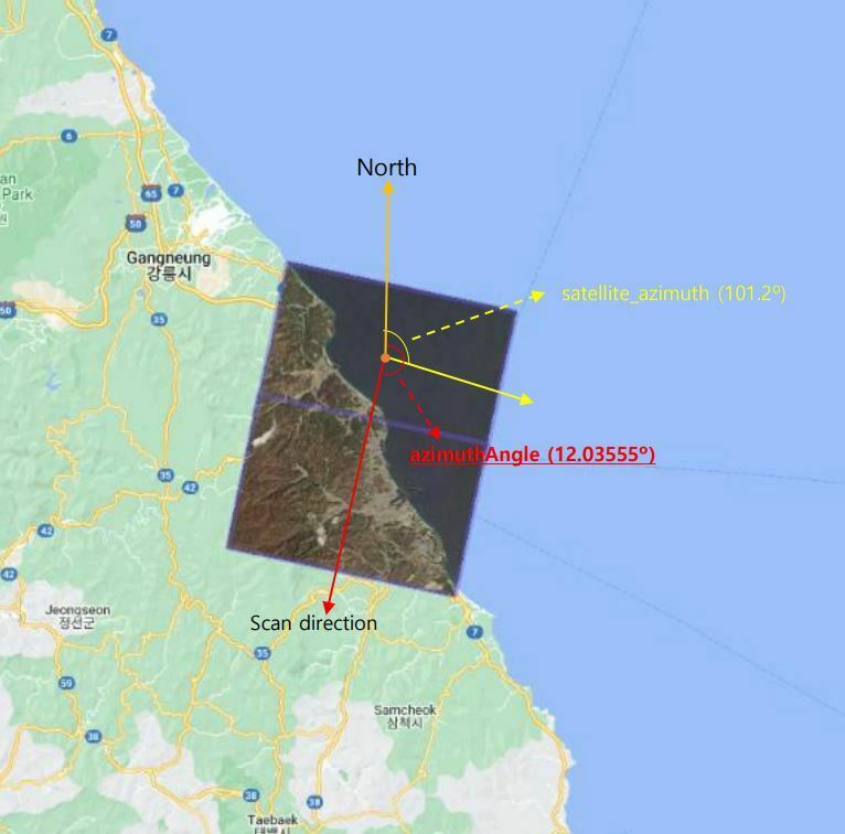
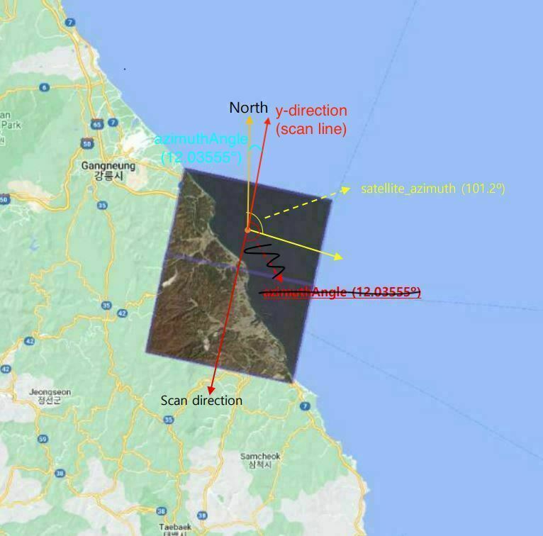
In case of "azimuthAngle" in General XML metadata, "azimuthAngle" means "The angle from true north at the image to the scan (line) direction at image center, in clockwise positive degrees" from the PLANETSCOPE PRODUCT SPECIFICATIONS document.

The "orbitDirection" of my PS2.SD L1B image is "DESCENDING" so I thought the scan (line) direction must be equal to a direction like following figure in consideration of how PS2.SD image composite were made.

However, I found that "azimuthAngle" is 1.203555e+01 in General XML metadata and it doesn't make sense because I think “azimuthAngle” must be at least over 90º.

So, I want to know what I missed...

Thanks. 

(I used ‘20190408_015325_76_105a_1B_AnalyticMS’ image.)


icon

Best answer by Mariana Curdoglo 14 February 2023, 21:22

View original

3 replies

Userlevel 3
Badge +5

Hello!

In simpler terms “azimuthAngle” is the clockwise angle between the image y-direction (line direction) and true north. In the above scene, this means that the scene is rotated 12.035555° from true north.

We’ve tried to correct the above image to match what the correct angle is. 


Hope this helps you better understand it!

Mariana

Userlevel 1
Badge +3

Thank you for your sincere response! I now understand what "azimuthAngle" truly means.

May I ask you another question, Mariana?

I checked other PSscene (PSB.SD) L1B data and found that some of the data have "satellite_azimuth" values over 180° (such as 273.5°, 277.7°), but their "view_angle" values are not negative (such as 2°, 5°) in the GeoJSON metadata.

However, if the "view_angle" value is positive, it means that the spacecraft is on the eastern side of the image when the image was captured and the "satellite_azimuth" value should be in the range of 0 to 180°. (I found this in the PLANET IMAGERY PRODUCT SPECIFICATIONS - May 2022.)

Did I misunderstand the meaning of "satellite_azimuth"?

Thanks again.

Userlevel 3
Badge +5

Hello, 

For SuperDoves or PSScene (PSB.SD), 

“satellite_azimuth” is the spacecrafts off track pointing direction, in degrees (0-360). So it is valid for scenes to have satellite_azimuth higher than 180°.

“view_angle” is the spacecrafts across-track off-nadir viewing angle used for imaging, in degrees with + being east and - being west. In the scene metadata this is a number between -25 to +25.

Mariana


Reply