Hi guys,
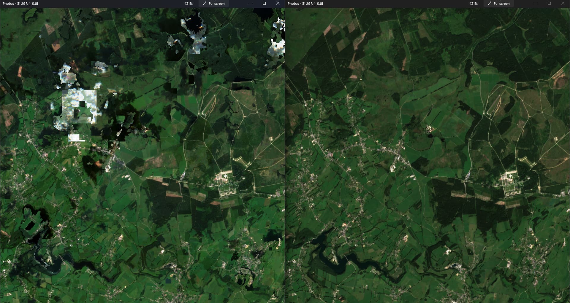
I use sentinel hub request builder (Requests Builder (sentinel-hub.com)) batch API to get satellite imagery for the whole of Germany for 2017 and 2020. I create a cloud-free mosaic using the script below between the dates 15. May and 15. September of each year. Otherwise, my settings are
- tiling grid: 20km
- resolution: 10
- output image format: TIFF
- COG output = true
The image for 2020 (on the right) looks fine, the one for 2017 looks severely distorted (see an exemplary part of one satellite image below). I now change the timeframe to 01.03. - 01.11. for 2017, but the clouds remain and many distortions (e.g., the black spots) exist. Does anyone know what is going on here and how I can fix it?
//VERSION=3

function setup() {
  return {
    input: [{
      bands: ["B04", "B03", "B02", "CLM", "SCL"],  //Requests required bands, s2cloudless mask and scene classification layer
      units: "DN"
    }],
    output: {
      bands: 3,
      sampleType: SampleType.UINT8
    },
    mosaicking: "ORBIT"
  };
}

function filterScenes (scenes, inputMetadata) {
  return scenes.filter(function (scene) {
    return scene.date.getTime()>=(inputMetadata.to.getTime()-8*30*24*3600*1000); //Defines the time range, e.g. from 1st June until 31st October counts 5 months with 30 days, 24 hours...
  });
}

function getValue(values) {
  values.sort( function(a,b) {return a - b;} );
  return getFirstQuartile(values);
}

function getFirstQuartile(sortedValues) {
  var index = Math.floor(sortedValues.length / 4);
  return sortedValues[index];
}
function getDarkestPixel(sortedValues) {
  return sortedValues[0]; // darkest pixel
}

function validate (samples) {
  var scl = samples.SCL;
  var clm = samples.CLM;

  if (clm === 1 || clm === 255) {
        return false;
  } else if (scl === 1) { // SC_SATURATED_DEFECTIVE
        return false;
  } else if (scl === 3) { // SC_CLOUD_SHADOW
        return false;
  } else if (scl === 8) { // SC_CLOUD_MEDIUM_PROBA
        return false;
  } else if (scl === 9) { // SC_CLOUD_HIGH_PROBA
        return false;
  } else if (scl === 10) { // SC_THIN_CIRRUS
        return false;
  } else if (scl === 11) { // SC_SNOW_ICE
    return false;
  }  else {
  return true;
  }
}

const visualizer = new HighlightCompressVisualizer(0.0, 0.2)

function evaluatePixel(samples, scenes) {
  var clo_b02 = []; var clo_b03 = []; var clo_b04 = [];
  var clo_b02_invalid = []; var clo_b03_invalid = []; var clo_b04_invalid = [];
  var a = 0; var a_invalid = 0;

  for (var i = 0; i < samples.length; i++) {
    var sample = samples[i];
    if (sample.B02 > 0 && sample.B03 > 0 && sample.B04 > 0 ) {
      var isValid = validate(sample);

      if (isValid) {
        clo_b02[a] = sample.B02;
        clo_b03[a] = sample.B03;
        clo_b04[a] = sample.B04;
        a = a + 1;
      } else {
        clo_b02_invalid[a_invalid] = sample.B02;
        clo_b03_invalid[a_invalid] = sample.B03;
        clo_b04_invalid[a_invalid] = sample.B04;
        a_invalid = a_invalid + 1;
      }
    }
  }

  var rValue;
  var gValue;
  var bValue;

  if (a > 0) {
    rValue = getValue(clo_b04);
    gValue = getValue(clo_b03);
    bValue = getValue(clo_b02);
  } else if (a_invalid > 0) {
    rValue = getValue(clo_b04_invalid);
    gValue = getValue(clo_b03_invalid);
    bValue = getValue(clo_b02_invalid);
  } else {
    rValue = 0;
    gValue = 0;
    bValue = 0;
  }
  return [visualizer.process(rValue / 10000) * 255, visualizer.process(gValue / 10000) * 255, visualizer.process(bValue / 10000) * 255]
}


