
Greetings

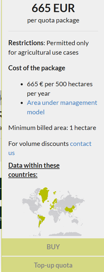
I am trying to purchase the “Planetscope Tier 2 package” but not getting the option to opt for the subscription. I’ve attached the image below for your reference. Could you please help me with this?

Kind Regards

Isaac


Hey,

These are probably greyed out because you first need a platform plan. These are the plans you will on the platform section of the pricing page.  You will also see them in the application where you go this screenshot.

The platform plans pay for access to the platform and include processing units which are consumed through usage of the platform, see: Processing Units Documentation.

Once you purchase a plan, like the Basic plan, you will be able to purchase the AUM Tier 2 data.

After you’ve done that, make sure to check out docs.planet.com for help getting started, including this guide for subscribing to and analyzing PlanetScope data


Thank you for the clarification ​@matt.ballard. This processing units to km^2 conversion is a bit confusing to me. one more question, If I subscribe to the “basic plan”, could I use the “AUM tier 2 package” without any additional processing units requirement? So the basic plan costs 83.25€ per month. does this mean  I need to pay 665€ on top of the basic plan to subscribe to this package?

Thank you.


Hey, yes that is correct, 83.25€ per month is the price of the Basic plan which gives you access to the platform. Once you have this, you can purchase Area Under Management Tier 2 data, which starts at 665€ for 500 hectares. I’d recommend the annual option for the Basic plan, as it comes with a slight discount and guarantees you will keep access to the PlanetScope data for the full 12 months.

The Basic plan includes sufficient processing units for most workflows up to 50 square kilometers/5000  hectares, so you should have enough processing units, however this will depend on how you use the platform. If you would like to share more details on how you plan to use the platform, I can provide some processing unit estimations


Hello, for my master’s thesis I want to do remote sensing of a few agricultural fields (300-400 ha). NDVI, NDWI etc are needed as I want to study how to streamline the process of agronomy with GIS. This could be an year long study of observing these fields (what is sown, growth, diseases, LST, etc.). However I am not sure which plan to use for this. Please let me know and thank you for your detailled and helpful answers.

Kind Regards

Isaac Vallabhapurapu


If you are using this for R&D, you could use the Exploration plan (300 EUR/year) which supports non-commercial use-cases and 1 package of Area Under Management Tier 2 (500 hectares) (665 EUR/year).


Thank you. So I could use the exploration package to study these fields for these variables. For example, now I want to observe these 3-400 ha land and as this is the high season, I might need to observe these land parcels once or twice a week atleast. If the exploration pack suits this purpose, then it is perfect for me.

Kind regards 

Isaac Vallabhapurapu


Yes, this should be satisfactory, if you do end up needing a few additional processing units, you can always add them later with “top up processing units”, but for 500 hectares, you should be good for most use-cases


Thank you so much ​@matt.ballard. You have been really helpful. 


Reply