Crop Identification

  • 26 April 2024
  • 6 replies
  • 0 views

Hello,

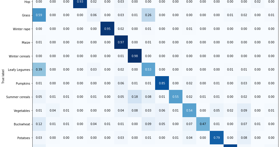
I’m trying to identify the crop culture (soybeans, corn, wheat, oats…), using satellite image or other data, but so far I didn’t find any way to do so.

Anyone has a clue of how I could do it?

Thanks


6 replies

You will have to dive a bit deeper into machine learning to do that.
I suggest you check the following blog post, which should give you an idea on how to start:

360db83263e79cba7951e7ba15aa4495131aa0f1.pngMedium – 28 Sep 22
83b2f979ca63f2bb0dbd4349346b0060a48fff8f.png

Area Monitoring — Crop Type Marker

Separating nuances of crop growth stages throughout the season

Reading time: 5 min read

That said, you will first need good label data.
For that I suggest you check the following locations:

Thank You,Sir!!!

It’s a great starting point

Thank you Grega.

Hello everyone

I recently started working with sentinel 1 data for the purpose of crop growth monitoring as my Ph.D research work. There is no slc image for my study area. Is it posssible to do close monitoring of crops using only grd data?

I have download both grd and slc image for the same area on the same date. My area of interest lies in 76.93 E. But that area is available only in grd and not in slc. I have opened the image in Snap toolbox.

As you can see the slc image contains ony half of the area covered in grd. Please, what should be done in this case?

Thanks in advance

Hi Moni

For SNAP I suggest you use the dedicated forum:

350ae18961827ffdec52cd57f776681a7db77364.jpgSTEP Forum 1d523305cf0d8e88190d7a3e938adfc71fbe06a3.png

STEP Forum

Discussions about the Sentinel Toolboxes

Ok thanks @william.ray . I will check there.

Reply