Hi! Has anyone insights into the quality of the UDM mask (clouds especially) for snow-covered regions?

Below you can see an image (2017-08-01, 45.97N, 7.35E) with some glaciers & snow and the corresponding cloud mask from the UDM layer.
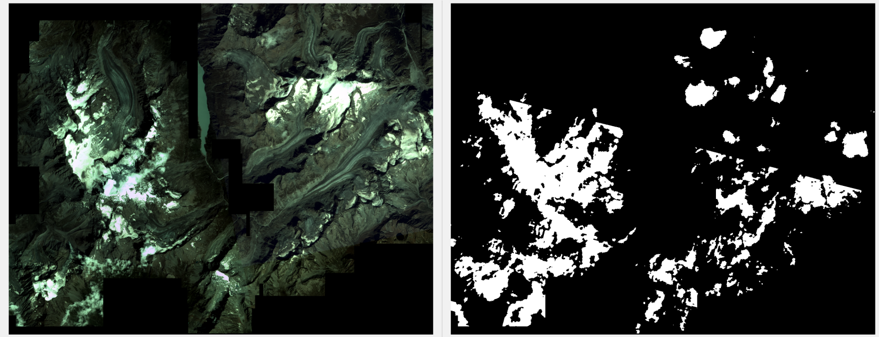

You can notice:

  1.  a lot of snow/ice areas are miss-classified as clouds
  2.  there is a line that separates the cloud mask into two sub-regions (the data comes from two different stripes); what's strange is that one sub-region has many more FPs than the other; looks like the algorithm behind is very sensitive to the underlying sensor

I’m wondering if it is common that snow & ice are frequently classified as clouds. I’m more familiar with the Sentinel-2 data and there the masks usually manage to capture the difference between snow and clouds.

Has anyone experience in this area?

Thanks!

Hello!

My name is Mariana Curdoglo and I am the Product Manager for PlanetScope images. I am hoping I can answer your questions. 

First, if you haven’t already please read through Usable Data Mask for information on how we build our cloud masks. As you mentioned, Sentinel-2 data manages to capture the difference between snow and clouds because they apply different processing and include SWIR.

Would you please share the scene ids with me (e.g 20231229_084930_74_24f3) so I can take closer look at what you are seeing. You also seem to be compositing two strips together, please provide all the scene ids along with how you have obtained the composites. 

Mariana


Dear Mariana,


Thanks for your reply!

  • Yes, I am aware that Sentinel-2 also utilizes SWIR for this purpose, which may indeed explain some of the differences.
  • Thanks for sharing the link. I had previously checked the metadata fields but hadn't read the methodology section until now.  After seeing the land cover classes used for training, I was wondering if glacierized mountain regions are also captured.
  • Yes, the image is indeed a composite (both temporally and spatially). To make it simpler, I selected only two strips from it (same day) which already highlight the issue (see the updated image below). Their IDs are:
    • 20170801_093916_1033
    • 20170801_093915_1033


Thanks a lot for looking into this and please let me know if there is additional information I could provide.

Codrut


Hello! Thank you for providing the scene ids.

The Usable Data Mask has a graph of the land classification used for the training data set. 

The usable data mask had a release on November 29, 2023 that improved classification of all bands. However, I do know that before this release we did have issues with differentiating between snow&ice pixels from cloud pixels. This was part of the reason why we invested resource in creating new training dataset and model. That’s what we are seeing in these two images. 

I know I am not being helpful, but I hope this provides a bit of context on what you are observing. 

Mariana


Hi Mariana!

Thanks for the update, makes sense.
It’s good to know that the snow vs. cloud issue was already on your list and that the masks will be improved with the new release.

Codrut


Reply