Feedabck for Tree Bloom Exercise

  • 14 April 2023
  • 5 replies
  • 246 views

Userlevel 3
Badge +8

Hello - I have run through the exercise and wanted to give back some feedback. 

Overall, great tutorial - and I’m so glad to see instructions to using Planet imagery for more detailed analysis!

A few thoughts:  

  1. Is there a reason why step 3 under "Preparing Data for Analysis" utilises geojson.io, instead of the native ArcGIS Pro tools to create the polygon (especially because it is used later in the classification exercise step 1)? 
  • When a ArcGIS Pro Project is created, a File Geodatabase (.gdb) with the name of the Pro project is also created that could be used from the start without having to venture out to another program. Users could right click on the "Databases" in the Catalog pane and create a new layer - then draw using the edit tools. Users could use the Locate tool to find the same location to zoom in their map interface to draw. By doing this (starting by creating a feature class instead of shapefile in geojson.io) it would cut out step 10, requiring them to export into a feature class and would stop them from having to create unnecessary extra files (i.e., the original shapefile in the table of contents to remove). 
  • If showing Geojson.io is key to providing more background on other tools, then another option is that users could also have imported the shapefile as a feature class directly by right clicking on the Database in the Catalog pane and selecting "Import" > "Feature class" then selecting the shapefile. 
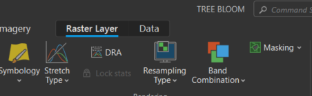
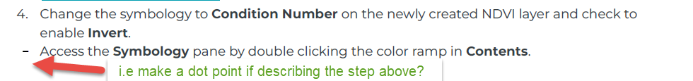
  1. For Step 26 - I would add the step "Click on the 'Raster Layer/Appearance' tab and then select Symbology" (note that the name of the tab changes depending on the version of Pro being used - for me there is no “Appearance” tab in Pro version 3.0.3, just Raster Layer). Or "Right click the layer to select Symbology", as users might not know that they need to open the Symbology pane in order to change the bands, and this tab is not shown in a screenshot provided. It is later described that they can double click on the colour bar, but again this could be moved up so that it is described the first tiem they need to change symbology, rather than later.
  1. Under "Normalized Difference Vegetation Index" - Step 4, this line item should be a heading, as the subsequent steps explain in further detail how to do this step. It is a bit confusing to read this as a single step, then read the next steps describing the process again. 
  1. Step 5-9 could be improved by providing a file of the island boundary. the boundary file is available on Esri ArcGIS Hub as a downloadble shapefile: https://hub.arcgis.com/datasets/SI::barro-colorado-nature-monument-boundaries/explore?location=9.152011%2C-79.845251%2C12.76
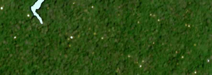
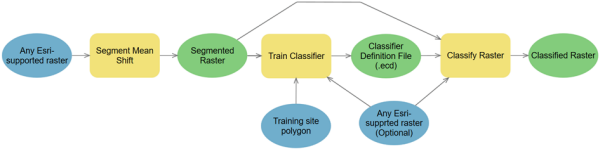
  2. Problem with the reclass approach - misses several blooms and categorises parts of the water that were accidentally digitised (if not using the island boundary file as above). I would recommend mentioning that other better segmentation tools exist, including a suite from Esri's Classification and Pattern Recognition toolset in the Image Analyst Extension: https://pro.arcgis.com/en/pro-app/3.0/tool-reference/image-analyst/an-overview-of-the-segmentation-and-classification-tools-in-image-analyst.htm & https://pro.arcgis.com/en/pro-app/3.0/tool-reference/image-analyst/understanding-segmentation-and-classification.htm
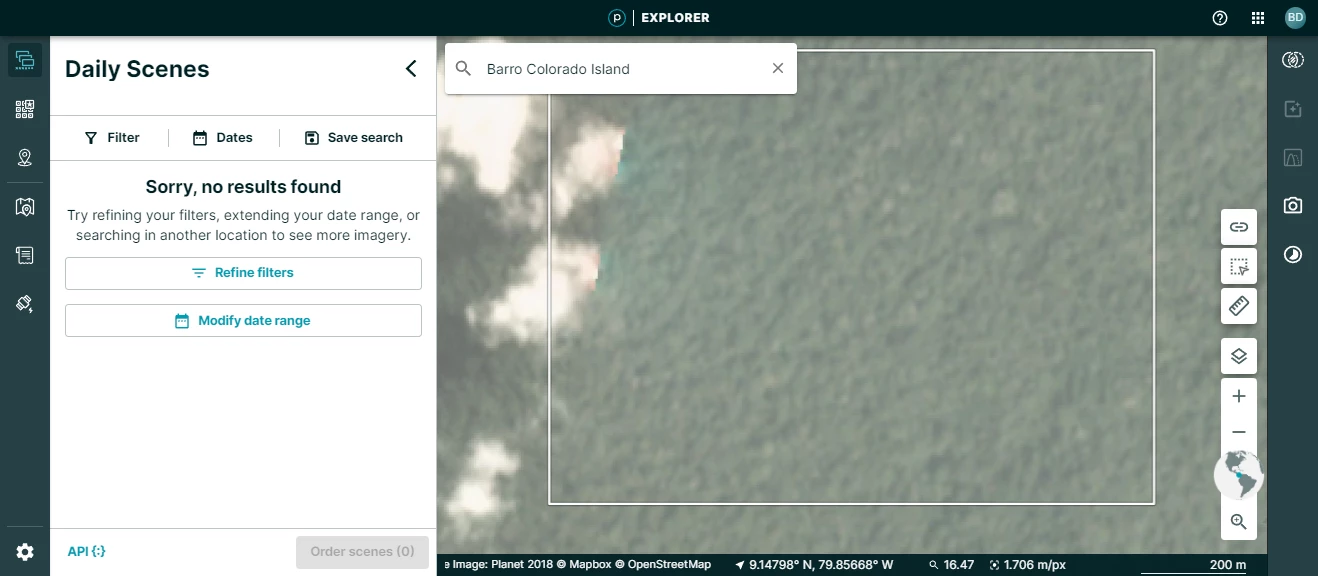
  1. For the exercise "Using Planet Products for Similar Orbital Bloom Analysis (optional)" > Planet Explorer, I am assuming users don't have access to Barro Colorado, as it will depend on the AOI of their monitoring subscription? When I search for Barro Colorado in search bar as described, I cannot see any imagery. The search term listed should be updated to say: 'Or your area of interest'.
  1. I am also unable to make a story using Stories for that area., as I do not have access to Barro Colorado in Explorer. Again, this could be updated to suggest that users need to utilise their own AOI.  

5 replies

Userlevel 7
Badge +13

Hi @Brittany,

Thank you so much for taking the time to not only do the exercise but also to give such in depth feedback. Your feedback is so helpful in will not only aid in this project but future projects, so thank you again. I will review all your feedback shortly and come back to you with some answers to of your questions :) 

Userlevel 7
Badge +13

Hi Brittany,

Thank you again for taking the time to give us such extensive feedback! As this is the first exercise like this that we have created we are eager to learn how to improve them going forward.

  1. Is there a reason why step 3 under "Preparing Data for Analysis" utilises geojson.io, 

As you guessed it, we decided to use geojson.io as a way to introduce more tools and show how to create an AOI outside of ArcGIS Pro and then showcase how to bring that data into the platform. Moving forward we will look into your tips on using the tools ArcGIS provides for AOI creation.

  1. I would add the step "Click on the 'Raster Layer/Appearance' tab and then select Symbology" (for me there is no “Appearance” tab in Pro version 3.0.3, just Raster Layer)

Thanks for noting this, we have added this information!

  1. Under "Normalized Difference Vegetation Index" - Step 4, this line item should be a heading, as the subsequent steps explain in further detail how to do this step. It is a bit confusing to read this as a single step, then read the next steps describing the process again. 

Thank you for noting this, we have made this change!

  1. Step 5-9 could be improved by providing a file of the island boundary/ flaws with the reclass approach. 

This is a great point, as this is for an introductory level, we wanted to take advantage of being able to teach new tools; in this case digitization. We completely agree with you in that this methodology can be improved and does leave out some of the blooming trees as well as include things such as water that should not be included. We added the link and provided the option for the user to now decide to use this boundary shapefile from Esri or to digitize. 

  1. Using Spatial Analyst toolbox

Completely agree with you that there are other tools that could have simplified steps, but we decided to use only the standard toolbox as we hope for this exercise to be used in a classroom setting and not all universities have access to other toolboxes besides the standard. In other exercise we will not only stick to the standard toolbox. 

  1. Planet Explorer/ Stories 

Thank you for pointing out that you could not access Barro Colorado, we have added a disclaimer and adjusted the language to recommend that users use their own AOI. 


Again thank you for your feedback, please be sure to let us know if you have any further feedback. The new version will be published to Planet University this week. We are currently working on other exercises that will help showcase how to use Planet imagery within a GIS and will let you know when those come out! :) 

Userlevel 3
Badge +8

Hello - Excellent, glad the comments could help! Thank you for taking comments on board, and appreciate the notes regarding introducing some tools that may not be required for an advanced learner. Very glad to hear more exercises are to come, these are very useful for my customers (as a Planet partner). I’m very happy to review adiditonal exercises - looking forward to seeing them in future 😊

Userlevel 1
Badge +1

To improve the experience to download Barro Colorado Island boundaries, here’s the link to the feature layer instead of the map:

https://stridata-si.opendata.arcgis.com/datasets/d92ad4c4de9344d8be3c43a573fe5fb9_0/explore?location=9.152011%2C-79.845251%2C13.47

It’s easier here to select only the island and no the surrounding peninsulas.

Milton

Badge +2

@Brittany   I’m a Partner Engagement Manager with Planet.  Thank you so much for providing such valuable feedback for our team, very greatly appreciated!  

Reply