Solved

Red/Green Color Fringing on Landslide Boundaries (Visual Basemaps) – Correct Workflow for Scientific Use?

  • February 12, 2026
  • 3 replies
  • 660 views

mohammed arkan
Forum|alt.badge.img+1

Hi everyone,

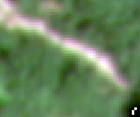
I am currently working with PlanetScope Visual Basemaps, which are licensed under an educational license. According to the product data and specifications, the positioning accuracy is approximately 4.77 meters in high mountainous areas (Kuala Lumpur, Malaysia).
 

The Observation: In my area of interest (hilly terrain), I have observed a distinct color artifact along the boundaries of landslides (the interface between bare soil and vegetation).

  • One edge of the feature consistently shows a Red fringe.

  • The opposite edge shows a Green/Cyan fringe.

I am trying to determine if this is an inherent characteristic of the data in steep terrain or something that requires specific post-processing.


My Questions:

1. Solutions for Color Fringing: What is the recommended method to correct this specific Red/Green separation? If this is caused by band misalignment, is there a standard tool or Python workflow (e.g., using AROSICS or similar) to realign the RGB channels specifically for Visual Basemaps?

2. Visual Basemap Specifications: Are PlanetScope Visual Basemaps expected to be free of these band-to-band offsets, given the stated <5m accuracy? Or is this type of spectral separation considered "within spec" for this product level when observing high-relief areas?

3. Scientific Readiness & Pre-processing: For the purpose of a scientific peer-reviewed paper, is this data considered "Analysis Ready" as-is? Or is there a mandatory "Preliminary Processing" protocol (e.g., geometric correction, band splitting, co-registration) that researchers must perform to make this data valid for academic analysis?


Any guidance on the standard workflow for using Visual Basemaps in rigorous scientific projects would be appreciated.

Best answer by elyhienrich

For others who have the same or similar questions:

1.Solutions for Color Fringing: The color fringing you’re observing could be due to band misalignment. However, it’s also possible that it’s a result of the inherent characteristics of the data in steep terrain. As for correcting this, there isn’t a standard tool or Python workflow specifically for Visual Basemaps. However, you might find it useful to explore the use of GIS software to analyze the images individually. This would require you to download the Surface Reflectance (SR) asset and analyze the images within a GIS Software. You can find more information on this in the Planet Imagery and Color Correction article.

2. Visual Basemap Specifications: PlanetScope Visual Basemaps are produced by an image registration process involving multiple frames ahead and behind an anchor frame. The band alignment is dependent on ground-lock in the anchor frame and will vary with scene content. For example, publication yield is expected to be lower in scenes over open water, mountainous terrain, or cloudy areas. The band alignment threshold is based on across-track registration residuals, currently set to 0.3 pixels for “standard” PlanetScope products (instruments PS2.SD and PSB.SD), 0.5 pixels to qualify for “test.” You can find more information on this in the Combined Imagery Specification document.

3. Scientific Readiness & Pre-processing: The data is considered “Analysis Ready” as-is. However, depending on the specific requirements of your use case, you might need to perform additional processing steps. These could include geometric correction, band splitting, co-registration, etc. 

If you have specific issues or questions please reach out to the support team for further investigation into your unique case.

3 replies

elyhienrich
Community Manager 🌎
Forum|alt.badge.img+17
  • Community Manager 🌎
  • February 17, 2026

Hi ​@mohammed arkan 

Our support team will be able to best help you, therefore I have opened a support ticket on your behalf copying the email you have registered with here on Planet Community 


mohammed arkan
Forum|alt.badge.img+1
  • Author
  • ‎‎ 🌱
  • February 19, 2026

HI ​@elyhienrich 
Thank you so much, I am very grateful and I hope to find a solution or answer to my question.
I have attached an images illustrating this problem.


elyhienrich
Community Manager 🌎
Forum|alt.badge.img+17
  • Community Manager 🌎
  • Answer
  • March 10, 2026

For others who have the same or similar questions:

1.Solutions for Color Fringing: The color fringing you’re observing could be due to band misalignment. However, it’s also possible that it’s a result of the inherent characteristics of the data in steep terrain. As for correcting this, there isn’t a standard tool or Python workflow specifically for Visual Basemaps. However, you might find it useful to explore the use of GIS software to analyze the images individually. This would require you to download the Surface Reflectance (SR) asset and analyze the images within a GIS Software. You can find more information on this in the Planet Imagery and Color Correction article.

2. Visual Basemap Specifications: PlanetScope Visual Basemaps are produced by an image registration process involving multiple frames ahead and behind an anchor frame. The band alignment is dependent on ground-lock in the anchor frame and will vary with scene content. For example, publication yield is expected to be lower in scenes over open water, mountainous terrain, or cloudy areas. The band alignment threshold is based on across-track registration residuals, currently set to 0.3 pixels for “standard” PlanetScope products (instruments PS2.SD and PSB.SD), 0.5 pixels to qualify for “test.” You can find more information on this in the Combined Imagery Specification document.

3. Scientific Readiness & Pre-processing: The data is considered “Analysis Ready” as-is. However, depending on the specific requirements of your use case, you might need to perform additional processing steps. These could include geometric correction, band splitting, co-registration, etc. 

If you have specific issues or questions please reach out to the support team for further investigation into your unique case.