


Our latest webinar in the Agile EO series highlighted Planet Maritime Domain Awareness (MDA) solution, a modern, proactive approach to maritime intelligence.
Whether you're interested in assessing maritime insurance risk or deterring illicit activities, the full webinar recording provides the technical breakdown you need.
Below are questions from the live event and answers from our product experts.
Questions & Answers
Q: What are the current vessel classes, and will more be added?
A: Currently, we classify detections into Military, Cargo, Tanker, and a catch-all “Other” class, alongside a Small Vessel class (for anything under 100 m). We are moving toward a more granular system with approximately 10 classes, including specific categories like bulk carriers, containers, and barges.
Q: What is the typical latency for receiving vessel detections?
A: Latency can vary, but we have seen it as low as 3-4 hours. On average, you can expect detections within 8 hours of capture, allowing for near-real-time monitoring of maritime activity.
Q: What is the frequency for an overpass on any particular location?
A: Planet offers coverage of strategic ocean areas with the following geometric collected coverage (GCC) rates: 70% in one day, 85% in two days, and 95% in three days.
Q: Does the vessel detection data include the underlying imagery?
A: We offer flexibility here. You can choose a "detections-only" package if you prefer to fuse the data with your own AIS signals or existing datasets. However, we also provide a standard package that includes the source imagery used to derive the detections.
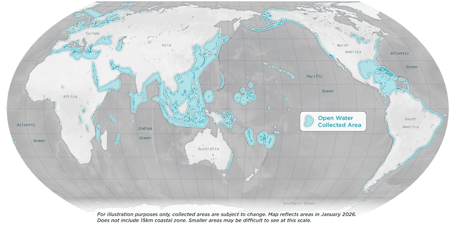
Q: Can you monitor in open water or only near shore?
A: We support over 20 million km2 of selective open water areas as well as 15 km offshore globally.
Q: What can be done if my specific area of interest isn't covered by the current open water coverage?
A: Our open water coverage is driven by customer interest and available bandwidth. If your area isn't currently covered, we evaluate requests on a case-by-case basis to determine the feasibility of expanding our capture to those new coordinates. Reach out to our sales team to see what’s possible.
Q: How is the vessel classification performed?
A: We trained a supervised classification model to recognize and distinguish different classes of vessels. As soon as an image is published within a customer’s area of interest, our system automatically runs this model on the image to extract and classify the vessels contained. For full details including dataset distribution see the tech spec.
Q: How accurate is the vessel detection algorithm?
A: We routinely iterate to improve our model’s performance addressing any issues as they arise. We measure our computer vision performance using three key metrics:
Precision: 87% (How often our detections are correct).
Recall: 85% (How many of the actual ships present are detected).
F1 Score: 86% (The blended average of precision and recall).
For full details see the tech spec.
Q: Do all detected vessels in this product have inferred length above 25 m? If so, what’s the reason for this cutoff?
A: Correct, in our experimentation we found 25 m to be the threshold at which performance was no longer satisfactory.
Q: Are there plans to increase autodetect of smaller boats (<25 m); most fishing vessels are smaller.
A: No, for vessels under 25 m we would recommend leveraging SkySat or Pelican imagery.
Q: Can the system detect submarines?
A: We have had some success identifying docked submarines, but detecting submerged vessels remains outside the current capabilities of optical satellite imagery. We are continuously working to improve detection in port environments.
Q: Does having a heading value imply that you are able to detect which end of the rotated bounding box is the bow?
A: Yes, our labeled dataset includes this information so the model trained from this dataset does predict the stern vs the bow.
Q: Can you single out only suspected dark fleet ships through the API for a certain area?
A: Through partner platforms like Theia provided by SynMax, ship detections fused with AIS data can single out only the suspected dark ships.
Q: Do you have corresponding AIS data with every detection?
A: Through partner platforms like Theia provided by SynMax, ship detections fused with AIS are surfaced, however some detections will not have AIS data associated as these are the dark ships of note.
Q: Do you use only visible imagery for detections? Do you combine it with SAR?
A: Correct, Planet’s Vessel Detection is derived solely from PlanetScope electro-optical data. We do not fuse with SAR data at this time.
Q: How are cloudy areas and false positives handled?
A: With every image that Planet publishes, there is an associated “Usable Data Mask” (UDM) file which classifies pixels into Clear, Cloud, Haze, Snow, or Cloud Shadow. We filter out cloudy and snow pixels to reduce false positives, but we do keep hazy imagery as we’ve seen success detecting vessels through haze.
Q: Is the imagery / ship location geo-accurate?
A: The ship detections geo-accuracy match the geo-accuracy of the underlying imagery. In ports and near-shore areas this accuracy is less than 10 m RMSE at the 90th percentile for cloud-free images. These images have ground control points which enable Planet to produce results with high geo-accuracy. As we move further out into open water, this accuracy reduces as there aren’t ground control points to map to. For more information see here.
Q: How is this service priced?
A: Pricing is based on a per square kilometer unit. The total cost depends on whether you are bundling the data with imagery, and we offer volume discounts for larger coverage areas. Reach out to our sales team to learn more.
Q: Is Planet MDA data available with standard site licenses for the software? Or is this an add on?
A: Planet MDA is an additional offering provided by Planet which can be licensed on its own or as an add-on to existing contracts.
Planet Maritime Domain Awareness Resources
- Contact a member of our team to get started with Planet MDA
- Learn more about Planet MDA: Solution overview and tech spec
- Watch the webinar recording on-demand
Have another question? Drop it below!
