Is it possible to download satellite data from google maps and overlay it with data obtained via S2 using the Python API?
e.g.:
    from io import BytesIO
    from PIL import Image
    from urllib import request
    import matplotlib.pyplot as plt

    Saeurig = [14.152730,51.213348, 14.174246,51.198163] # from above (coordinates for Sentinel Hub)
    Saeurig_bbox = BBox(bbox=Saeurig, crs=CRS.WGS84)

    Saeurig_mid_long = (Saeurig[0] + Saeurig[2]) / 2
    Saeurig_mid_lat = (Saeurig[1] + Saeurig[3]) / 2

    url = "http://maps.googleapis.com/maps/api/staticmap?center="+str(Saeurig_mid_lat)+","+str(Saeurig_mid_long)+"&size=800x800&zoom=15&sensor=false&maptype=satellite"

    buffer = BytesIO(request.urlopen(url).read())
    image = Image.open(buffer)
    width, height = image.size # getting size of the image

    ### TEST on evi2 spectra at a specific date for ROI
    wms_evi2_request = WmsRequest(layer='EVI2',
                                   bbox=Saeurig_bbox,
                                   time='latest',
                                   width=width, height=height,
                                   instance_id=INSTANCE_ID)
    wms_evi2_img = wms_evi2_request.get_data()

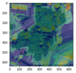
    plt.imshow(image)
    plt.imshow(wms_evi2_img[0], alpha=0.3)
    plt.show()
→ However, the images do not match completely (see image):